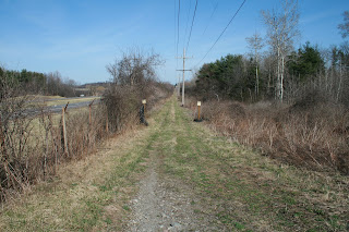
If you wish to see the canal, especially the enlarged canal, you can head over to the north side of the Thruway and travel down Maiden Lane Road and then onto Towpath Road for a bit (a dead end road). But the Thruway keeps you from looking for any early canal remains. Interestingly, if you are traveling along the Thruway (hopefully not driving) you can see a lot of early canal route, but it passes by too fast to make much sense of it all. So this area has always been of interest to me.
I looked on the Cayuga County GIS website and on Google Earth to see what might remain. The old fast trolley line was built along this route, covering over the first canal. But I did see spots that looked hopeful. With the permission of the land-owner; my wife, Lizzy the canal dog, and I took a walk on a very warm late winters day. I am happy we did, the leaves are already budding out and soon much of what I saw will be covered over for another summer.
Recall that the first canal is a contour canal, so we need to follow the lay of the land. This is very important, especially in this area, as the canal was built into the hillside. (Perhaps to skirt the muck-lands to the north?)

(Above) Here we are on the old trolley route, looking at a pond of sorts that I saw on Google Earth and Bing Maps 3-D. At this point, I am looking east toward Port Byron. My thought at this point is that the first canal is on the other side of this water. The water was likely impounded by the building of the trolley line. The Thruway is immediately to my left.

(Above) Here it is, just where I thought it might be. Filled with water, not all filled with trees and brush, at least for a very short length. The 1834 map below shows this section. The big loop is where the water is, and the photo is taken about where the canal cuts through thumb of land on the left side of the map. This section is almost pointed north. What is hard to see through the brush and trees is the lay of the land and how the canal was cut into the hillside.

If you read my book (go over to the Cayuga County Canals website and get it free), you might recall that the canal in this area was abandoned as soon as the enlarged canal was ready because the hillside keep sloughing off into the canal, and the winding route made it difficult to keep it in water.
 (Above) We then moved to the other end of the loop and wet area. I am standing on the towpath, and my wife, the bit of white and blue, is standing in the canal. The photos I took do not to justice to how well defined the towpath is at this point.
Once we knew where to look, we were able to follow the canal back toward the village. To the west of here, the Thruway has wiped out all traces of the canal, but we found what we thought might be more of the canal off in the woods.
(Below) Here is how close the Thruway is to this area.
 After looking over the land, I still don't know why Route 31, or what was 31 before it was 31, took to the hills. I can see why the canal hugged this area. They wanted to reach Sackett's Lock before dropping down to the Montezuma level. But why the road avoided the route is still a mystery. Of course with the Thruway and the trolley line, so much as been lost, and much of what we were seeing or believed we were seeing was pure speculation. I found a culvert under the trolley line and told my wife with some confidence that the trolley used the old canal as a drainage ditch. Sounds good, doesn't it?
So there you have it. Good stuff for canal wonks. Please remember, this is posted land and I received permission to go exploring.
No comments:
Post a Comment